Twickenham Riverside Development - Parking and Servicing Consultation
Results updated 5 Nov 2020
Thank you to all those who gave us their views.
For the latest updates please go to https://www.richmond.gov.uk/myrichmond/twickenham_redevelopment
Overview
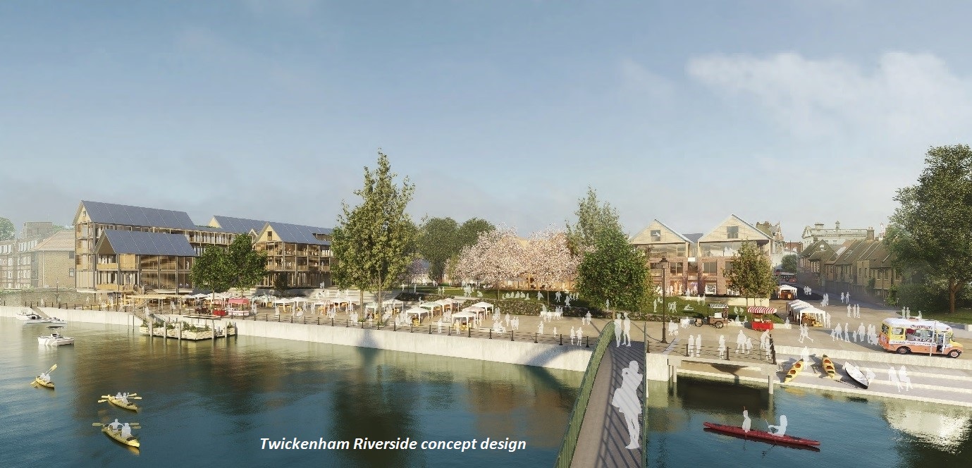
You may be aware that the Council is planning to redevelop Twickenham Riverside. Following feedback from residents, in 2019 the Council ran a Design Competition to find a new architect and concept design for the site, which includes the stretch of The Embankment between Wharf Lane and Water Lane.
By making the best use of the whole site, the redevelopment plans aim to open up the river, provide open space for all to enjoy, prioritise people over cars, transform the town centre, improve the local economy, enhance residents’ experience, and broaden Twickenham’s appeal as a destination. These proposals are also in line with the Borough’s Climate Change Strategy and Air Quality Action Plan, further details of which can be found here.
Parking and servicing
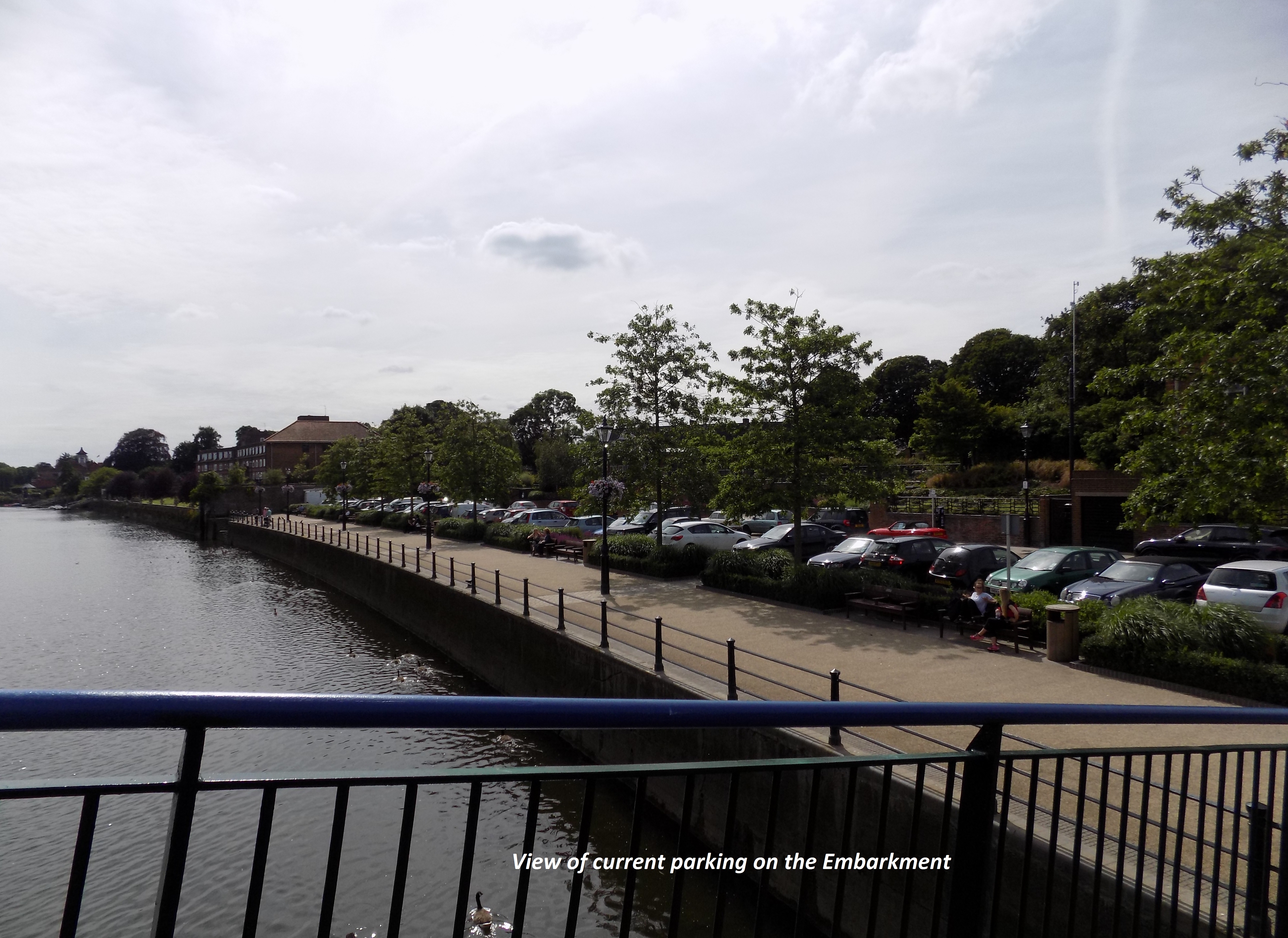
The decision has been made as part of the redevelopment plans to close The Embankment, between Water Lane and Wharf Lane, to all vehicular traffic along with the removal of approximately 82 parking spaces. This will be balanced with the creation of new bays, and re-designation of others, in the vicinity.
Although parking spaces will be removed from The Embankment itself, we will be ensuring that access and servicing requirements for Eel Pie Island and nearby properties are incorporated into the new scheme, as well as the provision of accessible spaces and electric vehicle charging points. This will allow for a scheme that can make the most of the unique river frontage in the centre of Twickenham that is currently dominated by cars.
The site is situated within the Central Twickenham Controlled Parking Zone (Zone D).
What we propose to do with parking
The proposals are summarised as follows:
1. The change in designation of approximately 93 on-street parking spaces, 62 of which are within 250m of the site with priority given to permit holders (including residents) near to the site
2. The creation of approximately 34 new on-street parking spaces within 800m of the site, ten of which are within 400m of the site
3. The introduction of an entitlement to allow Zone D business parking permit holders to park in the Holly Road car park (currently only those who pay the daily charge or those who have a valid Zone D resident parking permit may park in this car park)
4. The implementation of new double yellow lines, many of which will be at junctions, to improve road safety conditions in the area
It is also planned to improve the directional signage for the town centre car parks, investigate the feasibility of opening the Civic Centre car park to the public on Saturdays, and to consider measures to help prioritise parking spaces for short stay visitors on the lower levels of the Arragon Road multi-storey car park.
What we propose to do with servicing (loading and unloading) and access
A review of the servicing activity near to the site has been carried out, aimed at ensuring adequate provision is made for loading/unloading and access once the new development has been constructed.
Traffic surveys to assess the current needs in the area have been undertaken and discussions held with WSP, the new development’s design consultant, and representatives of local businesses, including those situated on Eel Pie Island.
The servicing and access proposals are summarised as follows:
1. A reconfiguration of the road layout in Water Lane which involves linking the service road between Water Lane and Wharf Lane (along the rear of Nos 3-33 King Street)
2. A two-way working of the southern sections of both Water Lane and Wharf Lane to enable access and egress for all vehicles
3. Provision of servicing areas (that is, for loading/unloading) in the area, including near to the Eel Pie Island footbridge
As well as proposing the above measures, consideration is being given to providing a new loading bay in King Street on its south side near to Water Lane.
All parking and servicing/access proposals are shown on the plans below:
Consultation
Development of all the above proposals for this area is aimed at meeting the needs for both parking and servicing/access. We are keen to hear your views about the proposals and any comments or concerns (including any suggestions or alternative measures) that you would like us to consider.
How to respond
Please complete the survey below. If you would like a paper copy of the questionnaire, please contact 020 8891 1411 and this will be posted out to you along with a pre-paid envelope for your response.
Should you wish to discuss any aspect of this consultation, please contact Michael Herd on 020 8487 5278.
Closing date for online or paper consultation responses and/or e-mails is Sunday 12 July 2020.
What happens next
All feedback received will be reported to the Council’s Transport and Air Quality Committee on Thursday 3 September 2020 prior to a decision being made on the way forward.
If you would like to register to speak at this committee, please contact the Council's Democratic Services team on 020 8891 7860 or email Democratic.Services@richmondandwandsworth.gov.uk. All requests to speak must be received by 12 noon one working day before the meeting.
Audiences
- Open to all
Interests
- Richmond Borough
Share
Share on Twitter Share on Facebook